

Mapping Iran’s Drone War Infrastructure
Mapping Iran’s Drone War Infrastructure
The network of production sites, bases, and launch nodes targeted in Operation Epic Fury
John Hendricks
Editor & Host, Global Recon
March 17, 2026 🕒 8 min read
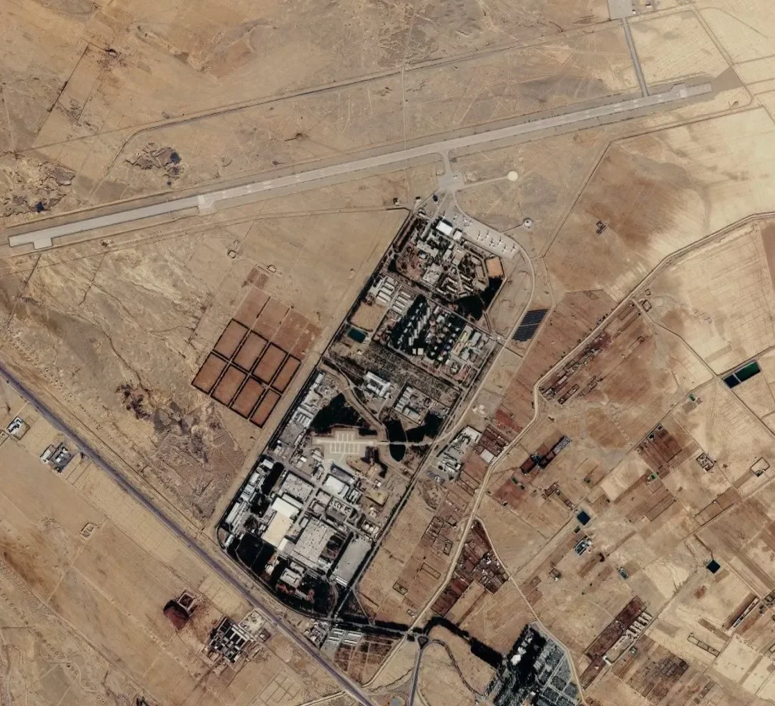
HESA Aircraft Manufacturing Industrial Company, Shahin Shahr, Isfahan Province. Pre-strike satellite imagery via Google Earth.
Why These Sites Were Hit First Operation Epic Fury didn’t choose its targets at random. The drone infrastructure that made Iran a global UAV power was visible from space and it appears to have been a major target in the opening phase of the operation.
Note: Damage assessments are still emerging, and details about specific strikes remain based on early reporting, open-source satellite imagery analysis, and initial official statements. This piece reflects the best available open-source picture as of publication.
The Map Was Already Drawn
Before the first strike crossed into Iranian airspace on February 28, 2026, Iran’s drone infrastructure was hiding in plain sight.
Iran’s drone program depends on a small number of critical facilities: production plants, training bases, and coastal launch infrastructure. Together they form the operational backbone of the country’s UAV ecosystem. Each node serves a specific role in the supply chain. When those nodes are struck, the system begins to fail.
The same network that supplied Russia with Shahed drones, enabled Houthi maritime strikes, and threatened Gulf shipping lanes for years also revealed the physical backbone of Iran’s UAV program. Taken together, these facilities form a map of the infrastructure that sustains Iran’s drone operations.
Operation Epic Fury made that map kinetic.
U.S. officials reported hundreds of targets struck across Iran in the opening phase of the operation, with CENTCOM stating that targets included IRGC command-and-control facilities, drone and missile launch sites, naval assets, and military airfields.
The strikes did not follow random logic. They followed the architecture of Iran’s military-industrial complex the same architecture visible in the physical infrastructure supporting the country’s drone program.
This piece maps that logic, site by site.
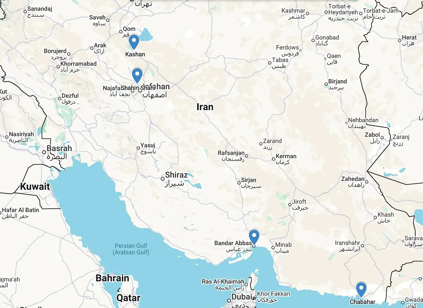
Iran UAV Infrastructure Network — four identified nodes targeted in Operation Epic Fury. Open source mapping via Google My Maps.
Node One: The Production Core — Shahin Shahr
The first question in dismantling any weapons program is: where is it made?
For Iran’s drone program, the answer has long pointed to Shahin Shahr, a city roughly 20 kilometers north of Isfahan and home to the Iran Aircraft Manufacturing Industrial Company known by its Persian acronym HESA.
Established in 1976 and sanctioned by the U.S. Treasury since 2008, HESA is widely understood to be a central node in Iran’s UAV manufacturing ecosystem, including systems in the Shahed family that have appeared in conflicts from Ukraine to the Middle East. The facility spans roughly 250,000 square meters of shops, hangars, and flight test infrastructure. A UN Panel of Experts previously confirmed HESA’s role in manufacturing the Ababil-T UAV and assessed it as a likely manufacturer of the Qasef-1 used by Houthi rebels in Yemen.
Satellite imagery taken before the strikes showed large industrial halls, expansive logistics yards, and a facility footprint that had visibly expanded over time consistent with production demand that had grown significantly since Iranian drones began appearing in bulk in the Ukrainian theater from 2022 onward.
On March 2, residents of Shahin Shahr reported thick black smoke rising over the city. Subsequent satellite imagery released by the Institute for the Study of War appears to show damage within the HESA complex, indicating the facility was likely struck during the opening phase of the operation.
The production node was a logical priority. That wasn’t a coincidence.
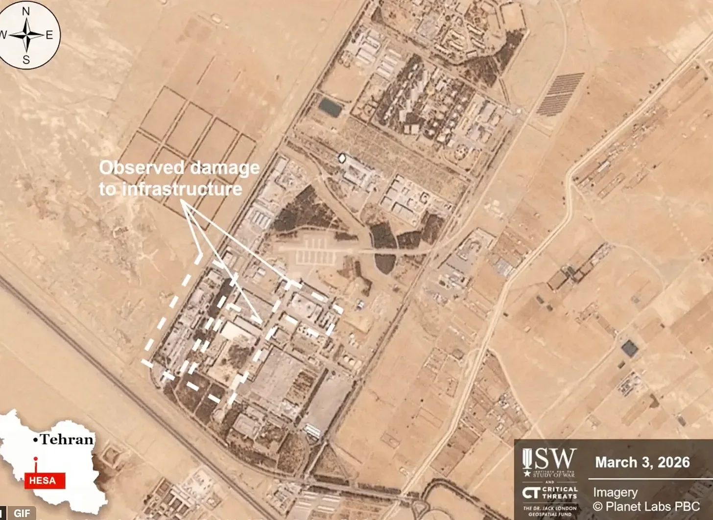
Satellite imagery © Planet Labs PBC, via ISW / Critical Threats, March 3, 2026.
Node Two: The Training Base — Kashan
Production without trained operators is inventory. Iran addressed that problem at Kashan.
The Shahid Karimi UAV Base which shares a 3,000-meter runway with Kashan Airport, roughly 190 kilometers south of Tehran is a widely reported UAV training and operational site used by the IRGC Aerospace Force. Washington Institute analysis identified Shahed-129, Mohajer, and Saegheh drones present at the facility in pre-conflict satellite imagery.
The base’s infrastructure profile long runway, adjacent hangars, open desert terrain to the east is consistent with sustained UAV training and staging operations.
Kashan represented both a training pipeline and an operational base in the same footprint. It is the kind of dual-function facility that makes it a high-value target in any campaign aimed at degrading Iran’s UAV operational capacity rather than just destroying hardware.
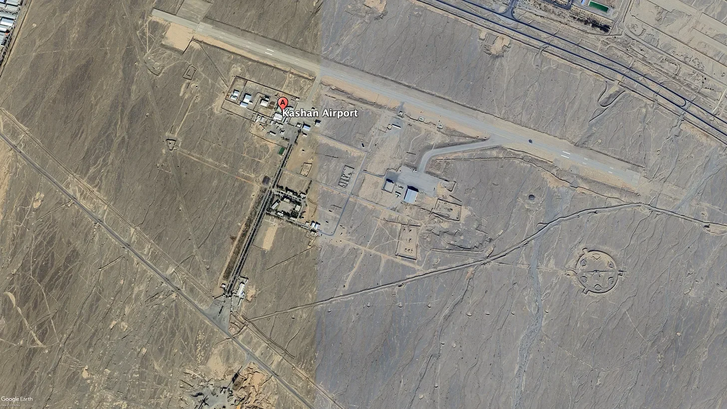
Kashan Airport / Shahid Karimi UAV Base, Isfahan Province. Runway and hangar infrastructure visible. Imagery via Google Earth.
Node Three: The Coastal Arc — Chabahar and Konarak
If Shahin Shahr built the drones and Kashan trained the operators, Iran’s southern coastline was where the program met the sea.
Iran’s coastal facilities in the Chabahar region sit in a position well suited for maritime UAV operations targeting shipping in the Gulf of Oman. The geography makes the case: open ocean access to the south, the Strait of Hormuz within operational range, and proximity to shipping lanes that have been the target of Iranian drone and missile strikes against commercial vessels in recent years.
Satellite imagery of the area shows airstrip infrastructure, IRGC naval basing, and support structures consistent with sustained operational use.
The Konarak naval basin nearby provides port infrastructure for surface combatants operating in the Gulf of Oman. Together, the Chabahar and Konarak area forms the forward edge of Iran’s maritime posture along its most strategically sensitive coastline.
Satellite imagery circulating online appeared to show damage to Iranian naval vessels and facilities at Konarak following the opening of Operation Epic Fury. CENTCOM statements referenced strikes on Iranian naval assets in the Gulf of Oman, though the full scope of damage to coastal drone infrastructure specifically remains unclear from open sources at time of publication.
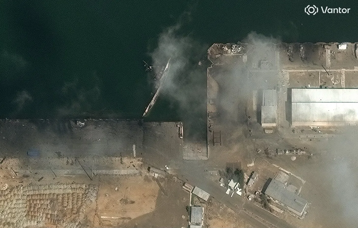
Konarak Naval Base, southern Iran. Satellite imagery © Vantor, March 2026.
Assessed by MizarVision as a Moudge-class frigate sinking at pier following U.S. strikes.
Node Four: The Sea-Based Platform — IRIS Shahid Bagheri
No assessment of Iran’s drone infrastructure written before February 28 would have been complete without its most ambitious component: the IRIS Shahid Bagheri.
Converted from a commercial container ship and commissioned into IRGC Naval service on February 6, 2025, the Shahid Bagheri was Iran’s first domestically produced drone carrier. Capable of operating Shahed-series UAVs, rotary-wing assets, and other drone platforms from a 180-meter flight deck, it represented a significant expansion of Iran’s drone reach: a mobile launch platform able to operate wherever the IRGC Navy could sail.
Reports indicated the vessel had been struck while berthed at Bandar Abbas in the opening phase of the operation. If confirmed, its loss would eliminate Iran’s sea-based UAV projection capability before it ever launched a combat mission.
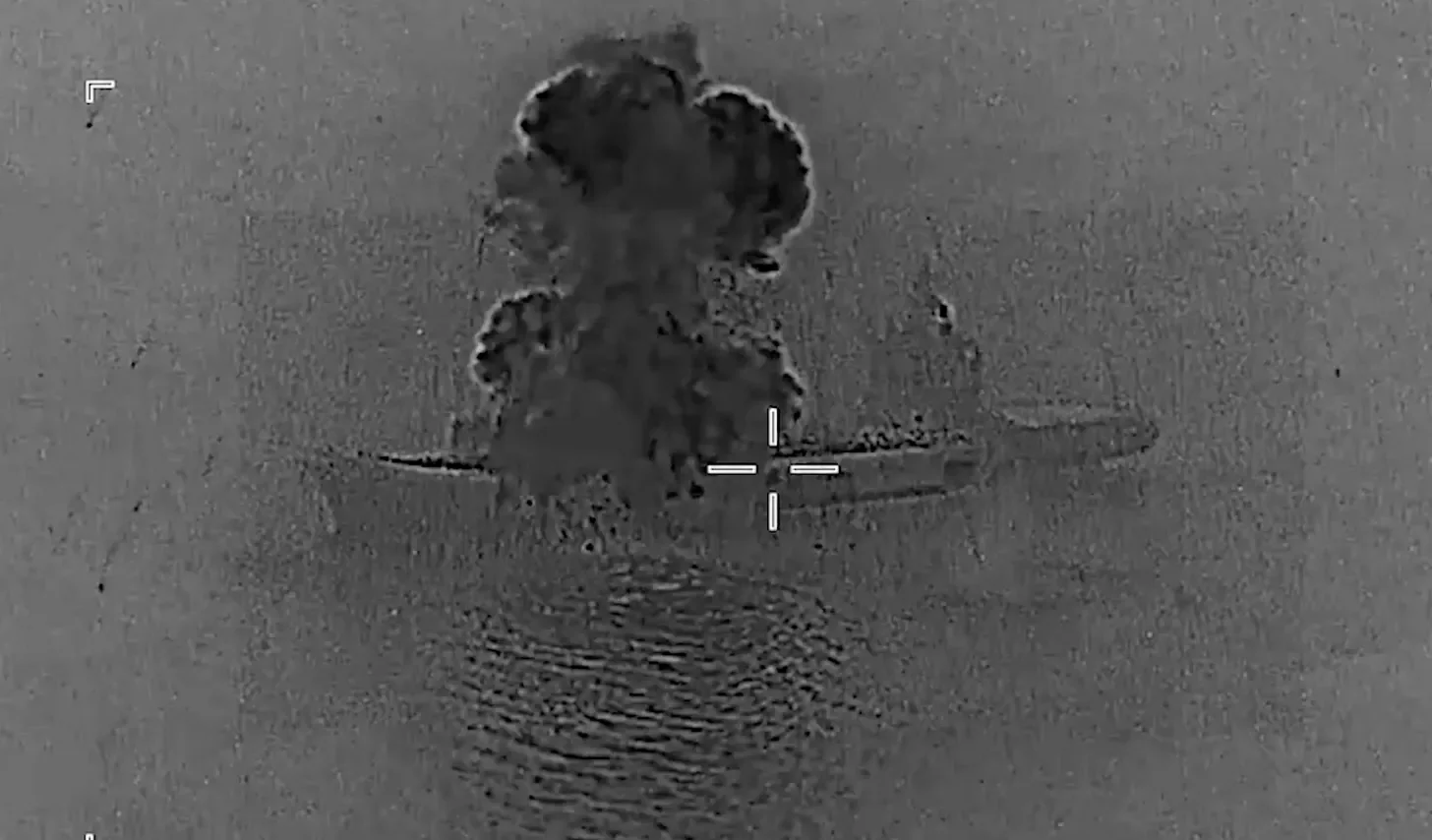
IRIS Shahid Bagheri drone carrier under strike. Image via U.S. Central Command, March 2026.
What the Target List Reveals
The pattern across these strikes if early reporting holds is not random destruction. It is the systematic dismantling of a supply chain.
Production at Shahin Shahr. Training at Kashan. Forward coastal launch capability at Chabahar and Konarak. Sea-based power projection aboard the Shahid Bagheri.
Each node served a specific function. Each was identifiable through open-source imagery and analysis long before the first strike flew. Several appear to have been on the target list.
This is what distinguishes the drone program from Iran’s other military capabilities. Ballistic missiles can be hidden in mountain tunnels. Nuclear facilities can be buried under reinforced concrete. But industrial-scale drone production requires factory space, logistics yards, runways, and port infrastructure all of it visible from 400 kilometers up, all of it fixed in place.
The program’s greatest operational asset its industrial scale was also its greatest strategic vulnerability.
Conclusion: The Visibility Problem
Iran’s drone program spent years leveraging the gap between what its adversaries knew and what they were willing to act on. That gap closed on February 28.
The infrastructure mapped here was never truly hidden. It was documented in UN sanctions designations, Treasury notices, independent analysis, and commercial satellite imagery accessible to any researcher. The production lines, the training bases, the coastal launch sites all of it was visible, all of it was analyzable, and all of it was apparently targetable.
Operation Epic Fury didn’t discover Iran’s drone infrastructure. It destroyed what open-source analysis had already found.
That’s the lesson that outlasts this conflict. In an era of commercial satellite constellations and open-source intelligence, fixed military infrastructure is a permanent liability.
The map is always being drawn. The only question is who acts on it first.
John Hendricks is an OSINT analyst and founder of Global Recon. Follow on X: @IGRecon
Subscribe to Unclassified with John Hendricks on Substack.
Related Analysis
ANALYSIS
The mind is not a vessel to be filled but a fire to be kindled: A Discussion with former KGB Officer Jack Barsky
Jack Barsky, former KGB officer, explores Intelligence, Insight, ana tne power of critical thinking in shaping perspective.
ANALYSIS
Do not wait to strike till the iron is hot; but make it hot by Striking: A discussion with Hrulf, the founder of the Norman Brigade
Hrult, tounder ot me Norman Bngaae, shares Insignts on taking Imtiatlve, shaping opportunity, and leading with strategy.